Showing posts with label Coastal Expeditions. Show all posts

Monday, February 26, 2024

Folly Beach's Two Famous Boats--One Barely Retained, One Barely Remains

2008
The boundless Folly Beach landscape is a stunningly beautiful tangled blue web of saltwater creeks, rivers, and estuary marshes. It is this dazzling network of rising and ebbing saltwater that decidedly makes it a water sportsman’s wonderland of swimming, boating, fishing, surfing, kayaking, stand-up paddleboarding, and the home of two famous boats, one with a Hurricane Hugo connection.

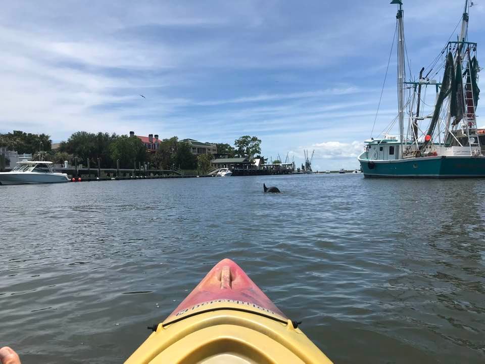
I came across one of Folly's notable maritime landmarks for the first time while paddleboarding Folly Creek in 2015. Coastal Expedition's had a small office located in a wooden planked building next to Crosby Fish and Shrimp at that time.

I boarded my rented long board, shoved off into the warm waters of Folly Creek, and paddled towards Bowen's Island Restaurant. Not long into the paddle, the object of my interest came into view with its stern sticking out of the water along the edge of the marsh grass. It had been there since its abandonment. I took my first pictures of the solitary wreck.

2015

2019
I have revisited the sunken boat off and on since that first encounter. It has changed over the years. Aside from the Skull-and-Crossbones being placed on it, the creek's salty water and weathering elements since have ravaged the wooden denizen of the deep. My last visit was in November, 2022.

If you are interested in seeing this famous sunken Folly boat for the first time, I would suggest you do it sooner than later, because the maritime clock is ticking down to once upon a time there was a sunken boat on Folly Creek.

2022

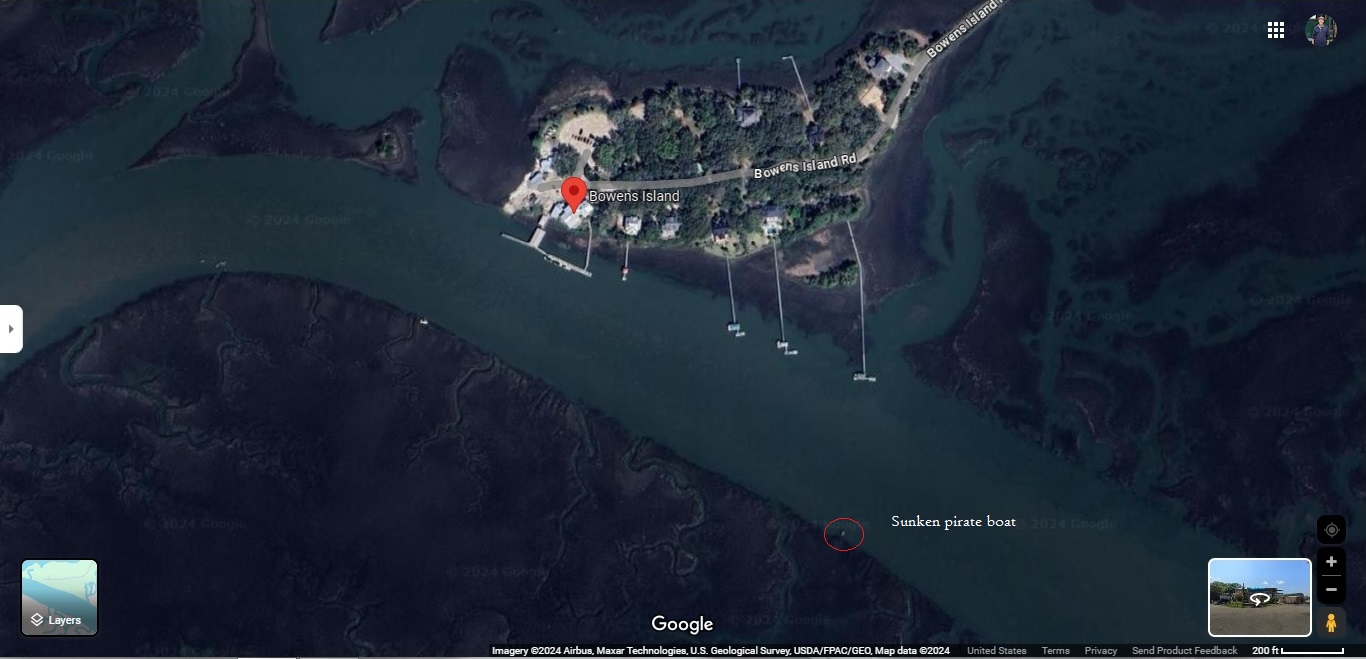
Location of sunken boat on Folly Creek.

In the decades after Hurricane Hugo swept the other famous Folly Boat to its resting place next to Folly Road in 1989, it became a sounding board for community residents, who painted and repainted it with political slogans, declarations of love, and other messages. In 1996, two killer whales were painted on one of its sides. It was irresistible to passersby, who would stop to have their pictures taken next to it. Perhaps, you were one of them.

Then, in September 2017, Tropical Storm Irma came into town and along with a high tide swept the boat up from its iconic roadside location and crashed it into a private dock on Sol Legare Road where it remained with an uncertain future, even after over two thousand dollars of donations was raised to save it. At one point during the next two years, the over 20 ton behemoth was precariously considered for the scrap pile. However, a James Island bar owner came to the rescue.

In December of 2019, Crews with Limehouse and Sons used a crane and a flatbed truck to move the boat from its marshy resting place to The Barrel on Folly Road. Even though it is on private property, it is both visible and accessible from Folly Road. Looking at Google maps, it shows the bar is pinned as permanently closed, but the painted boat still remains at that location.


The Folly Boat by itself is just an aging, metal hull, but when painted, it was both inspirational and controversial through the years. It produced some beautiful art works and sometimes emitted words like a drunken sailor. Town officials often debated whether it was a landmark or an eyesore, but it was the everyday person that settled the matter in favor of a local icon. Recently, it may have lost its luster among newcomers who couldn't possibly fathom its allure, but long time residents of the Lowcountry remember it like they do Hugo. Hey, it even had a Facebook fan page where you can see pictures posted by painters and lovers of the Hugo boat, though the last one posted was in 2021.

You, the reader, may have pictures of these two famous boats of your own or even a story recounting your own encounter with them while traveling Folly Road to Folly Beach or paddling Folly Creek. Go ahead and share them if you so desire.

Friday, July 21, 2023

A Paddle on One of Charleston's Premiere Waterfront Meccas--Shem Creek

I waited my turn at the Shem Creek Boat Landing to slip into the creek's liquid embrace either coming or going at a steady flow--depending on the tide--along and through the edges of its green-framed space. In all the years I have traveled its undeviating currents, I have never once seen its smooth-skinned submariner breaking the water's surface on the quieter side of the Coleman Blvd bridge. I wonder if before the oyster-covered concrete columns were sunk into the mucky bottom of its murky waters, whether that capricious observation were unerring. I could ask the brown pelican, but truth be told, I have never really heard them make a sound. The feathered fisherman most likely would only silently give me a vertical nod with a stiff upper beak.

Once you pass through the bridge's shadow to the Charleston Harbor side, the scene of grass-lined waters transforms to an unbroken stretch of sundrenched, weatherworn wooden docks, waterfront restaurants, and a variety of gas-powered watercraft of all sizes jockeying for an ideal place to disembark their thirsty and hungry passengers. Boisterous conversation and music popping like shrimp in shallow waters fills the salty air. Take your pick, the long list includes Tavern and Table, Red's Ice House, Water's Edge, Sunsets, Saltwater Cowboys, Vickery's Bar and Grill, and if you are feeling venturesome, the audacious eatery called The Wreck of the Richard and Charlene. The Wreck has been on the creek for over 30 years, recently on Netflix's popular show Outer Banks. Red's Ice House remains my favorite for an after-paddle beer and Saltwater Cowboys for a roof top Island Mule.


Along this stretch of the creek, I pause my paddle to linger and soak in the energized atmosphere. If it is a Sunday afternoon, I will ease my paddleboard up to the dock of Saltwater Cowboys to enjoy the tunes of the band playing on its outdoor deck. Flocks of pelicans gather to feast on the fish scraps tossed into the water from charter and local fishermen's catch of the day. I soon find myself surrounded by a group of dolphins arching above the creek's surface. They have come to join the party. Meantime, one of the waterway's resident oddities, the traveling tiki bar, comes into view. Maybe, I can coax them to toss me an icy beer to counterbalance the hot southern sun and humidity.


Moving on, the scene changes from restaurants and taverns to the thick steel and tall nets of the mighty shrimper fleet that makes the creek its home base. I find myself amused by the names painted on their hulls and sterns, such as Tuff-e-Nuff, The Hagg, Family Thing, Miss Paula, Carolina Breeze, Winds of Fortune, Richardson Bros II, Magwood's Pride, and the not so unusual and dignified, Bridget.


Passing Vickery's, the pillars and rails of an elevated boardwalk rises up where the water mingles with the spartina grass of Shem Creek's expansive marsh. If it is low tide, you will see white egrets and herons prowling the shallows along its grassy edges. Sightseers and tourists with cameras in hand traverse its planks for a better view of the creek and Charleston skyline. In the distance, the spires of the famous Ravenel Bridge towers over the marshscape. SUPers and kayakers attempt to dodge the fishing lines of locals trailing down from above as boats coming and going cruise past, occasionally followed by the whoosh of a graceful, low gliding pelican, so low you could almost see the tips of its wings gently graze the water's surface.

Continuing on, I paddle past the covered ending to the boardwalk and Hadrian's Point, where the creek finally opens into the spacious stretch of water leading to Crab Bank Island and the Charleston Harbor beyond--to the left, Sullivan's Island and Fort Sumter, to the right, Patriot's Point and Charleston Harbor Resort. It is here I stretch my legs over the side of my paddleboard with my feet barely touching the water, lean back, and let the currents and wind take over as I soak in the wonder of it all.


Points of interest:

1) During its history, Shem Creek has been known by many names. The original Sewee inhabitants called it shemmee, but what the word exactly meant is unknown. After the arrival of the English, the creek's name depended on who owned its surrounding land. It was Sullivan's Creek, Dearsley Creek, Rowser's Creek, Lempriere's Creek, and a short time, Distillery Creek. During the time no one had claim of the lands around the creek, it was always referred to as Shem Creek.
 
2) Shem Creek's first restaurant was called Lorelei Seafood Restaurant. It was located where the Shem Creek Inn stands today. It was known for a mural on its dining room wall entitled "The Song of the Lorelei," depicting the mythical siren whose enchanting song lured homesick sailors into the ocean's depths.

Saturday, December 24, 2022

Coastal Expeditions' Shark Tooth Beach Drop on Big Crab Bank Island in Charleston Harbor--A Hunt of Fun

Shark teeth are a highly sought-after relic of the past. Like the gold rush days of the West, where miners sifted streams for the king of nuggets, shark teeth hunters sort through the tidal deposits of the barrier island beaches of Charleston in search of the mother load of shark teeth, the teeth of the Megalodon.

There are several shark teeth tours offered in Charleston by different outfitters. We chose Coastal Expeditions' Shark Tooth Beach Drop, scheduled from October 16 to March 14. The tour's destination is a man made island in Charleston Harbor called Big Crab Bank Island, formed by the dredging of the harbor. This tour is not to be confused with the Morris Island Shark Tooth Beach Drop offered beginning March 15. A mistake I made. I should have read the details that this was a trip to Shark Tooth Island, a.k.a. Big Crab Bank Island.

Coastal Expeditions' Coast Guard-certified vessel for this tour departs from their Shem Creek location. Bottlenose dolphins and Eastern brown pelicans are present to be seen as the vessel heads down Shem Creek and out into Charleston Harbor past Small Crab Bank Island. On the morning of our tour, there were no dolphins in the creek, and the pelicans were sparse, but numerous other species of birds were spotted and named by the naturalist. It is just the nature of wildlife viewing. It can be hit or miss. Wildlife makes no promises and do what they do at their leisure.


You will enjoy views of the downtown skyline, Ravenel Bridge, Fort Sumter, and other iconic landmarks on the trip to the island. After reaching the island, we departed directly onto the beach by way of a plank extended from the boat with the assistance of Coastal Expeditions' naturalist. He did not join the group on the hunt. I do not know if he gave any instructions to anyone on how to spot fossils in the sand.

Once on the beach, we left the group and began our search, as did most everyone else. Most of the island is a bird sanctuary. You are not allowed in those sections. The tidal deposits of tiny shells and other ocean debris were sparse and scattered across the beach. It wasn't long after starting the hunt my companion found our first shark tooth. She had the keener eye. It was strange how a fair number of clamshell bits and pieces are shaped like a shark's tooth, often fooling you into thinking you spotted one.

The majority of the group's finds were small. The chances of finding a Megalodon tooth are slim to none on Big Crab Bank Island, but not impossible. What comes to shore is dependent on the rising and falling tides. We found 10 in all, with the largest about one and a quarter inches. Other finds included interesting shells and bones.

The boat ride is relaxing. The narrative by the captain and naturalist was informative. The hunt takes patience and a keen eye. The walk on the beach the day of our trip, in the warm Charleston sun for a December day, was pleasant. The tour duration was 3 hours, which included a 30-min boat eco-tour each way. The price is $65 for adults and children 12 and under $40.

Shem Creek Flagship, 514 Mill Street, Mount Pleasant, SC

Wednesday, July 19, 2017

Cape Romain Lighthouses Tour Hosted by Coastal Expeditions and the Sewee Center--Merging Historic Charisma with Beauty and Splendor

On Sunday, the adage "good things come to those who wait" was confirmed. For two years, I have been wanting to do the Cape Romain Lighthouses Tour, but for various reasons ranging from conflicting schedules to being sold out, the highly coveted opportunity had been as elusive as the red wolf. There are only four tours scheduled through the year and timing is everything. The next tour is scheduled for October. I almost did not make this one. It too was sold out. I had my name put on the waiting list in case there was a cancelation and as fate would have it, lightning struck. I am thinking the threat of thunderstorms forecasted for the day of the tour, which was July 16, may have presented me the necessary thunder. Thank you, Mother Nature.


Lighthouse Island is located in Cape Romain, a National Wilderness Area. Coastal Expeditions suggests participants wear appropriate footwear for water and pluff mud, preferably something waterproof and attached to your feet. Anyone experienced with stepping into the dark-brown viscous material knows losing your footwear is always a possibility. Since I do not own boots, and highly unlikely to wear them if they were available, my choice was between flip flops and tennis shoes. So, I put on the latter option, grabbed my camera and a banana for a snack, hopped into my truck and headed to the Sewee Center on Highway 17 in Awendaw for a pre-tour presentation.


Upon arrival, I checked in along with about forty other people for the hour-long slide presentation outlining the history of the two lighthouses on the island. It was delivered by Tom Graham, a College of Charleston grad with a degree in Biology. He has dedicated his time and energy for the past 20 years to the preservation and restoration of the lighthouses. The shorter conical lighthouse, standing 65 feet, was built in 1847 and the octagonal lighthouse, standing at 150 feet, was built in 1857. At the age of three, Tom was present when the 1857 light was taken out of service in 1947. The two lighthouses are the only structures left on the island, the light keeper's residences are just a pile of bricks and rubble.


From the Sewee Center, we headed for McClellanville and its boat landing on Pinckney Street where Coastal Expedition's Caretta Ferry awaited. Storm clouds were looming in the near distance to the south as forecasted.

Lighthouse Island is approximately a winding six-mile trip through the Cape Romain estuary from the boat landing. A smiling Captain William Christenson welcomed us aboard, gave us some necessary safety reminders, and the location of the life preservers. Then, he delivered his first of many humorous witticisms, "If you should happen to fall off the ferry, we will toss you the life ring, but truthfully, all you need to do is stand up. The water in the estuary is only about 3 to 5 feet deep at the most." For the next hour, Captain William talked about life in the estuary. He instructed, "Take a deep breath," paused and then added, "You are breathing the cleanest air in the world."


Cape Romain Refuge is a Class 1 Wilderness Area. It is a place where humans haven't developed roads, pipelines, or other industrial infrastructures. What we see today is pretty much what the Indians saw hundreds of years ago as they canoed through its winding waters. Besides supporting the cleanest air, it is home of the cleanest water in the world, and that is the result of the estuary's four necessary components: water, spartina grass, pluff mud, and oysters. Spartina grass is the only plant that can grow in the estuary's salty water due to its ability to filter the salt out of the water and secret the excess out through special glands.

The most thought-provoking part of Captain Will's narrative was when he talked about the estuary's most distinguished amphibious sojourner, the loggerhead turtle. Born on the sandy beaches of the estuary's barrier islands, the tiny hatchlings who survive their demanding and dangerous scamper to the water enter the ocean and spend the next thirty years in the Atlantic currents swimming the Gulf Stream to the North Atlantic Drift to the Canary Current to the North Equatorial Current and back to the Gulf Stream. Reaching maturity at age thirty, it returns to the beach it was born on and lays its eggs to continue the cycle of life and then returns to the currents. The odds of reaching maturity are 1 in 1000.


At the start, just a small silhouette in the distance, the white and black octagonal lighthouse was now a colossus rising high above the island's trees. The captain eased the Caretta into the spartina grass and the ramp was deployed. We waded through the ankle-deep water and traversed the bush-lined path to the lighthouses. For the next 45 minutes, I took pictures and walked among the brick strewn ruins of the keeper's houses. I touched one of the huge iron treads of the circular staircase now callous from rust and imagined ascending the 150 feet to the light room at the top--a task the light keeper performed daily. At present, imagine is all you can do, the light room at the top where the Fresnel lens was housed is off limits to the public for safety reasons. Possibly, within two years, you will be able enjoy a 360-degree panorama of the stunning surrounding vistas.


Lighthouses of old are remarkable relics of ingenuity and for many of us today, fascinating pieces of history and highly sought after subjects of photography. They were outwardly, geometrically simple in design, inwardly, an amalgamation of ingenuity all wrapped in a mystique as beguiling as an old grandfather clock. The Cape Romain Lighthouses Tour by Charleston Expeditions merges that historic charisma with the beauty and splendor of the Cape Romain estuary. The tour is both informative and entertaining thanks to the knowledgeable hosts. If you like boat rides, water, wildlife, and lighthouses, I highly recommend the Cape Romain Lighthouses Tour.


Departure Points:
Sewee Center
5821 Highway 17 North
Awendaw, SC

McClellanville Boat Landing (Boat)
Pinckney Street
McClellanville, SC

Thursday, September 24, 2015

SUPing Folly Creek--Full Of Natural Beauty, Fascinating Wonders, And Teaming With Life

As the warm, morning sun rises above the Atlantic surf and washes over the sandy beachfront on the Edge of America, the ever impinging light unendingly confirms an already well established verifiable fact. The boundless Folly Beach landscape is a stunningly beautiful tangled blue web of saltwater creeks, rivers, and estuary marshes. It is this dazzling network of rising and ebbing saltwater that decidedly makes it a water sportsman’s wonderland of swimming, boating, fishing, surfing, kayaking, and stand-up paddleboarding.

From the southern tip at Folly Beach Park to Lighthouse Inlet, Folly Beach has seven miles of beachfront ideal for sunning and swimming. The Edwin S. Taylor Fishing Pier is one of Folly's more prominent landmarks. Stretching 1,045 feet into the Atlantic surf, it has some of the best saltwater fishing in the area. The Washout has gained prominence as one of the more popular surfing spots along the East Coast. With 6.4 square miles of water, there is plenty of shoreline for the boater and kayaker to explore. However, for this article, I will be focusing on what Folly Beach has to offer the renting SUPer.


Although, you can rent paddleboards and transport them to wherever you want, there are two main entry points for paddleboard renting on Folly Beach--Folly Creek and Folly River. The choices and locations are Coastal Expeditions on Folly Road next to Crosby Fish and Shrimp, Charleston Outdoor Adventures next to Bowens Island Restaurant or Charleston SUP Safaris on Center Street at Flipper Finders.

After surveying the options, I chose Coastal Expeditions on Folly Creek. In my judgment, Folly Creek was the better access point. There was far less boat traffic and it was closer to more secluded areas of the surrounding estuary. Admittedly, the ultimate deciding factor that tipped my selection in favor of Coastal Expeditions came from a conversation I had with a couple who just came back from a paddleboarding excursion on Folly Creek. They mentioned seeing a partially sunken boat and that little bit of information peaked my interest.


I paid the $28 for 2 hours rental fee at a small office located in a wooden planked building and made final preparations for the paddle. It was a hot, humid afternoon, so I purchased a cold bottle of water at Crosby Fish and Shrimp, put my cell phone in the requested dry bag for safe keeping when not taking pictures and made the short walk to the pier. On the way, I passed a fisherman busy sorting through his catch of blue crab. Two large shrimp boats bearing the scars of their many years of service were moored at docks close to the fishing pier/boat dock where the guide awaited my arrival. It was high tide. The skies were partly cloudy blue. A challenging breeze was present. With dry bag and flip flops secured, I boarded the long board and shoved off into the warm waters of Folly Creek. It was going to be a great paddle.


My planned course would take me towards Bowens Island and the eclectic Bowen's Island Restaurant--a longtime favorite oyster stop for locals and a Hollywood icon—it was featured in the movie "Dear John." I wanted to take pictures of the restaurant from the water. I paddled past a huge estate with a large swimming platform before entering the more secluded stretch of Folly Creek where marsh grass and tall trees lined the shoreline leading to the restaurant. The brisk breeze at my back pushed me along at a pretty decent clip as I navigated and surfed the cresting waters. A mile into my paddle, I arrived at my desired destination and took numerous pictures of the old restaurant. I sat on my board with my feet and legs dangling in the water and soaked in the calming ambience and soothing sounds of my surroundings.


On the way back, I encountered the partially sunken boat—a ghostly relic from Hurricane Hugo. I curiously observed five great white heron foraging the edges of the marsh grass until they tired of my presence and spent a considerable amount of time being entertained by a group of six dolphins with young at their sides swim around my paddleboard. One dolphin afforded me the rare treat of seeing it totally breach the surface of the water. Sadly, my cell phone was packed away in the dry bag at the time. Thunder rumbled in the distance and the skies began to darken. It was time to leave the beautifully enriching scene.


In comparison to other paddleboard locations throughout the Charleston Lowcountry, I would consider Folly Creek a favorite, followed closely by Morgan Creek on the Isle of Palms. The Folly Beach estuary is a stunningly beautiful tangled blue web of saltwater creeks, rivers, and marshes full of natural beauty, fascinating wonders, and teaming with life.


Coastal Expeditions Folly Beach
2223 Folly Rd
(843) 406-0640